Winds of winter to sweep in as weather bodies issue alerts for Ireland and Scotland
and live on Freeview channel 276
The high winds are expected to descend from the north, impacting Scotland first before arriving here with the warning in place from Friday morning/ afternoon.
The windy conditions are expected to continue through to Saturday with the warning extended to take in parts of England and Wales as well as Ireland and Scotland.
Advertisement
Hide AdAdvertisement
Hide AdThe Met Office Forecast for the north states: “Potential for a period of very strong winds to develop across northern Scotland on Friday afternoon then extend south during the evening.”

The Met Office has advised that people may see some delays to road, rail, air and ferry transport and that there is “a slight chance of some damage to buildings, such as tiles blown from roofs”.
There is also “a small chance that some roads and bridges could close” and a “slight chance that power cuts may occur, with the potential to affect other services, such as mobile phone coverage.”
Met Eireann meanwhile has highlighted the Met Office warning for the north and issued its own status yellow marine warning for the whole of Ireland for roughly the same period from early Friday morning to Saturday afternoon.
Advertisement
Hide AdAdvertisement
Hide Ad“Gale warning for all coasts of Ireland and on the Irish Sea- Northwest to north winds will reach gale force 8 or strong gale force 9 on Thursday night, Friday and Saturday on all Irish coastal waters and on the Irish Sea,” it has stated.
Stay safe in a storm
The Met Office has the following general advice for drivers on how to stay safe in a storm:
“Even moderate rain can reduce your ability to see and be seen. A good rule of thumb is ‘if it’s time for your wipers, it’s time to slow down’. If heavy downpours are expected, avoid starting your journey until it clears.
If you can, choose main roads, where you are less likely to be exposed to fallen branches and debris and flooding.
Use dipped headlights if visibility is seriously reduced.
Advertisement
Hide AdAdvertisement
Hide AdGusts of wind can unsettle vehicles – grip your steering wheel firmly with both hands. This is particularly important when planning to overtake.
Keep an eye out for gaps between trees, buildings or bridges over a river or railway – these are some of the places you are more likely to be exposed to side winds. Ensure that you maintain enough room either side of your vehicle so you can account for it being blown sideways.
Roads will be more slippery than usual in wet weather – be sure to give yourself more time to react when approaching a hazard. Increase your following gap to at least four seconds from the moving traffic in front.
Keep your eyes peeled on the road at all times as spray from other vehicles can suddenly reduce your visibility. Remember it affects others too, so anticipate their actions and be prepared.
What to do when the road is flooded
Advertisement
Hide AdAdvertisement
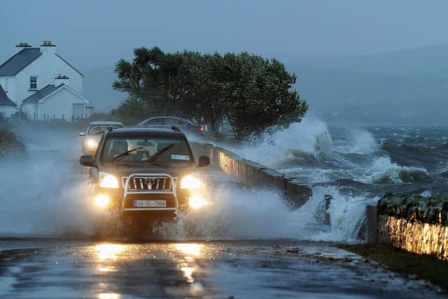
Hide AdIf the road is flooded, turn around and find another route. The number one cause of death during flooding is driving through flood water, so the safest advice is turn around, don’t drown.
Although the water may seem shallow, just 12 inches (30cm) of moving water can float your car, potentially taking it to deeper water from which you may need rescuing.
Flood water also contains hidden hazards which can damage your car, and just an egg-cupful of water sucked into your car’s engine will lead to severe damage.
Never drive through flood water. Turn around.
Keep an eye out for cyclists, motorcyclists and pedestrians. Remember to give vulnerable road users including cyclists, motorcyclists and pedestrians more room than usual. They are more likely to be blown around by side winds – always keep a safe distance.”