Hallowe’en weather: Charts indicate Derry parade and fireworks may pass before worst of Storm Ciarán
and live on Freeview channel 276
Weather advisories have been issued on both sides of the border.
The Met Office has issued a yellow warning for rain for the whole of the North cautioning that ‘heavy rain is likely to bring some flooding and transport disruption’ to some parts.
Advertisement
Hide AdAdvertisement
Hide AdParts of south Ulster have been badly affected with widespread flooding in south Down and south Armagh and across the border in north Louth in Leinster.

The heavy downpours have thus far been concentrated in the south and east of the country with Met Éireann predicting that Storm Ciarán will pass close to the south coast of Ireland on Wednesday, November 1.
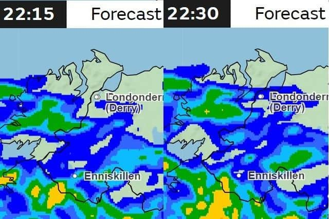
Met Office charts are projecting that heavy rain will not arrive in Derry until after 10.15pm and 10.30pm when the main parade, drone and fireworks displays will have been completed.
Met Éireann’s Atlantic charts are also indicating the heavy weather will arrive in the north west closer to midnight and in the early hours of Wednesday.
Advertisement
Hide AdAdvertisement
Hide AdRevellers are, however, advised to be prepared for the worst.

In its forecast for the North as a whole Met Éireann said: “Spray and flooding could lead to difficult driving conditions and some road closures
“Delays or cancellations to train and bus services are possible
“Homes and businesses could be flooded, causing damage to some buildings
“Some communities may be cut off by flooded roads.”
Advertisement
Hide AdAdvertisement
Hide AdMet Éireann said rain will continue in Ulster with localised flooding this afternoon.
Rain in southwest Munster is expected to spread north eastwards through the afternoon and evening with a chance of spot flooding. Highest temperatures of 9 to 13 degrees with light to moderate south easterly winds, fresher in the west and southwest.
A wet night with widespread rain, and spot flooding possible, is expected with lowest temperatures of 7 to 10 degrees with moderate to fresh south to southeast winds.
Later Wednesday and on Thursday, Storm Ciaran will bring falls of heavy rain and strong winds. Current indications suggest the heaviest rain and strongest winds will be in Munster and Leinster with flooding likely.