Adrian’s ‘Wild Mountain Way’ trek across Donegal was a labour of love


I woke up very early to another beautiful day and feeling on top of the world.
I got everything ready and departed for Malin Town. My main target for the day was Slieve Snaght which towers up in the middle of the Inishowen Peninsula. I had climbed it on numerous occasions in the past but this would be an approach from a direction which was new to me and had a long track leading to it from Carndonagh.
Advertisement
Hide AdAdvertisement
Hide AdNone of that should cause a major problem but the five kilometre crossing from Malin Town to Carn, as Carndonagh is called by the locals, had a major issue and that related to my safety on the road. The road is a very busy one; but it is also quite narrow and without a dedicated footpath for most of its length. In these circumstances, I decided to leave my rucksack in Carn, as, without it, I would have more mobility, which would be very necessary if I had to move off the roadway to avoid oncoming traffic. While travelling towards the start point, I was considering my options as to where I should leave my gear. The junction with the exit road leading up to Slieve Snaght seemed as if it would be a good place to try first.
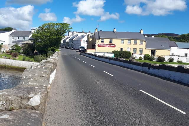
On nearing the outskirts of Carndonagh, I found the exit and pulled in off the road in front of a low wall that surrounded the front of an old-style house that appeared to be uninhabited. I got quite a start when a man’s head popped up from behind the wall and it was even more of a surprise when I recognised the man as Raymond Doherty. Raymond, reminiscent of myself, had been at one time the owner/manager of a small clothing factory.
We hadn’t seen one another in years but there was mutual recognition. When I explained to him what I was proposing to do, Raymond gave me permission to leave my belongings behind the walls of what had been his parents’ house and which he was presently tidying up. He also confirmed that the track I intended to take was the correct one to use to get to the mountain.
This mountain is well named because, even when it is not wearing its white icing sugar-like cap of snow, the winds whistling around its peak can be very cold, even when blowing from the usually warmer south. It was beneficial for me that this was not a windy day.
Advertisement
Hide AdAdvertisement
Hide AdI eventually ran out of track and had to take to the open hillside through tough tall heather, aiming firstly for the top of a lesser hill, Tullymore Hill (Tullach Mór – Big Round Hill), at 356 metres, in the hope that I could then cross over to a ridge that ran between Crackmeenarevog (Cnoc Mín an Réabhóg – Hill of the Mountain Pasture of the Linnet/Lark or The Hill of the Reed) and Slieve Snaght. On closer inspection, I thought better of the latter section and headed directly up towards Slieve Snaght instead. There was no track to follow apart from the odd bit of sheep track. The climb was sometimes very steep, which meant the going was quite tough in places.
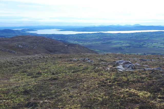
I reached the top at a little after 6pm to be rewarded with a magnificent panorama of the north coast of Ireland, eastward to Fair Head and Rathlin Island, with the Scottish mainland appearing behind that again. The Mull of Kintyre and the Scottish Islands made their appearance to the northeast.
In mythology, this Slieve Snaght was seen as one of the most important mountains in Ireland. In 1825, it became important as a base for mapping Ireland as part of the Ordnance Survey’s Principal Triangulation. It was the site for the trial of a pioneering surveying device, a limelight, that could be used to show across long distances, if it worked as expected. This device, which generated a very high intensity light by blowing an oxygen/hydrogen mixture over a sphere of lime, was lit on Slieve Snaght and was then seen at Divis, 67 miles (108 km) away, near Belfast. This was the first time a limelight was used for surveying. The surveyors, who were all serving army officers and who included Thomas Drummond, the inventor of the limelight, camped on the summit and built a wall to shield themselves from the weather.
A circular wall can still be seen on the summit but I can’t confirm if this is the same wall as the surveyors used in 1825. Whether it is or not, the present wall is often used for the same purpose as the 1825 wall was used for in its day, protection against the harsh weather on the mountain. Some things haven’t changed in almost two hundred years!
Advertisement
Hide AdAdvertisement
Hide AdMy plan now was to head southwest along the ridge and to eventually drop down adjacent to Umrycam Service Station. That, in turn, would be the starting place for the following day’s jaunt.
The next high point on the ridge was Slieve Main (514 metres), which lay between Slieve Snaght and the next high point, Crocknamaddy (Cnoc na Madaigh - Hill of the Dogs). Getting to Slieve Main demanded a descent followed by a climb up again. When I was travelling over and onwards past that spot, a view of the approach to Crocknamaddy opened up and I saw that continuing in that direction was going to lead me to an encounter with fences.
Deciding that a change of strategy was needed and having found that a crossing point over the nearest fence was available to me, I crossed there and headed directly downwards to the hedge at the bottom of the field. I scrambled through the hedge and dropped down onto a narrow road that serviced the two houses sited along it. Glad was I to get onto the road and change out of my boots and into the walking shoes that had come with me for just such a situation. I had been less than happy coming down through the fenced pasture because I wasn’t sure of what kind of a reception I might receive if my presence should be noticed. As luck would have it, the question didn’t arise as it seemed that no notice had been taken of my descent.
I now took to the road for a couple of kilometres and was soon at the Umrycam Service Station. While the service station was the end of my walking for the day, there was still the problem of how to get back to Malin Town, some twenty-two kilometres away, for my car. I hadn’t yet thought through how I was to get there. A customer at the service station offered to take me as far as the North Pole, not the North Pole of Santa Claus and ice and snow, but rather the North Pole Bar that was situated five kilometres along towards Carn, at the junction of that road and the road to Clonmany. Taking him up on his offer, I reached the bar, but it was now getting late in the evening and, with little chance of another offer of a lift, I phoned a taxi in Malin Town and hired him to bring me back to my car. During my time sitting at the bar waiting for my lift, I got a great longing for a nice cool pint of beer but I had to be satisfied with a glass of orange juice, being precluded from such an enjoyment by my upcoming drive home.
Advertisement
Hide AdAdvertisement
Hide AdI satisfied myself with rerunning the route in my head with its trek of 26 kilometres and a total ascent of almost 900 metres for the day.
○ ‘Wild Mountain Way: Donegal on Foot and Alone’, by Adrian N. Gallagher, is available to buy at various outlets across the NW. The publication can be ordered directly from https://www.facebook.com/WildMountainWay. All profits go to Donegal Down Syndrome.