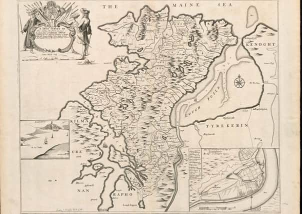
Ancient map paints fascinating picture of Derry and Inishowen


The map is well-known to historians but now, through the Boston Public Library in the United States, it is available for users worldwide to view or download.
The map has the grand title of: “A true survey of The Earl of Donagal’s Barronie of Enish Owen containing the two adjacent harbours of Lough Foile and Lough Suillie, ye Isle of Inche, Culmore, and Londonderry”.
Advertisement
Hide AdAdvertisement
Hide AdIt was engraved by Sutton Nicholls and published by Philip Lea, map maker, both of London, in 1690.
It is based on earlier maps attributed to the work of English military surveyor, Thomas Phillips, who produced surveys of Irish forts and harbours.
Thomas Phillips may have based his map on an earlier map of Inishowen published in 1661.
Mark Lusby, Project Co-ordinator for The Friends of the Derry Walls, brought the map to the attention of the ‘Derry Journal’.
Advertisement
Hide AdAdvertisement
Hide AdHe says: “It is unusual for such an historic map to be so accessible to people interested in local history and the Boston Public Library is to be congratulated on its dedication to the creative educational use of its cartographic holdings.
“As well as showing the relationship between the new Plantation City of Londonderry and its Inishowen hinterland, the map is fascinating for the details on the 17th century Walled City which the map-makers have included.”
The map shows a representation of Major General Kirk (of boom-breaking fame) holding a map of the City Walls.
Also included is a view of the Walled City as it would have been approached from the river, with clear depictions of the now-missing Water and Coward’s Bastions, Shipquay Gate and St Columb’s Cathedral without its spire.
Advertisement
Hide AdAdvertisement
Hide AdA map key shows that the main four streets had names such as Silver, Gracious and Shambles but were, at the same time, also known by the name of the nearest gate.
The map can be viewed and downloaded via the Boston Public Library website at www.maps.bpl.org
Meanwhile, throughout 2016, The Friends of the Derry Walls is organising a series of talks about the Walls and a discussion on the 1690 map and other historic maps will be included in the programme. See www.theDerryWalls.com